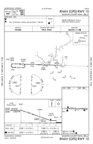
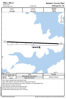


KMLJ - Baldwin County Rgnl
Located in Milledgeville, United States
ICAO - MLJ, IATA -
Data provided by AirmateGeneral information
Coordinates: N33°9'15" W83°14'29"
Elevation is 384 feet MSL.
Magnetic variation is -04° East View others Airports in Georgia
Operational data
Special qualification required
Current time UTC:
Current local time:
Weather
METAR: KMLJ 280035Z AUTO 10006KT 10SM OVC050 23/18 A3026 RMK AO2
Communications frequencies: [VIEW]
Runways:
| RWY identifier | QFU | Length (ft) | Width (ft) | Surface | LDA (ft) |
| 10 | 92° | 5509 | 100 | ASPH | |
| 28 | 272° | 5509 | 100 | ASPH |
Airport contact information
Address: Milledgeville United States
