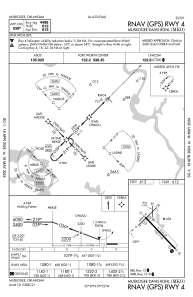
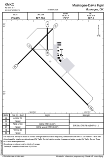


KMKO - Muskogee-Davis Rgnl
Located in Muskogee, United States
ICAO - MKO, IATA -
Data provided by AirmateGeneral information
Coordinates: N35°39'28" W95°21'42"
Elevation is 611 feet MSL.
Magnetic variation is 06° East View others Airports in Oklahoma
Operational data
Special qualification required
Current time UTC:
Current local time:
Weather
METAR: KMKO 290753Z AUTO 13003KT 1/4SM FG VV002 18/18 A2986 RMK AO2 SLP107 T01780178
Communications frequencies: [VIEW]
Runways:
| RWY identifier | QFU | Length (ft) | Width (ft) | Surface | LDA (ft) |
| 04 | 45° | 4498 | 75 | ASPH | |
| 22 | 225° | 4498 | 75 | ASPH | |
| 13 | 135° | 7202 | 150 | ASPH | |
| 31 | 315° | 7202 | 150 | ASPH | |
| 18 | 180° | 1904 | 60 | ASPH | |
| 36 | 0° | 1904 | 60 | ASPH |
Airport contact information
Address: Muskogee United States