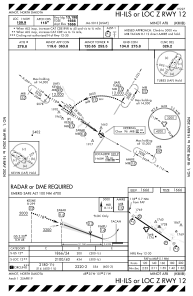


KMIB - Minot Afb
Located in Minot, United States
ICAO - MIB, IATA -
Data provided by AirmateGeneral information
Coordinates: N48°24'57" W101°21'29"
Elevation is 1666 feet MSL.
Magnetic variation is 07° East View others Airports in North Dakota
Operational data
Special qualification required
Current time UTC:
Current local time:
Weather
METAR: KMIB 271355Z AUTO 03019KT 10SM CLR 05/00 A2992 RMK AO2 SLP147 T00540004
Communications frequencies: [VIEW]
Runways:
| RWY identifier | QFU | Length (ft) | Width (ft) | Surface | LDA (ft) |
| 12 | 125° | 13198 | 300 | OTHER | |
| 30 | 305° | 13198 | 300 | OTHER |
Airport contact information
Address: Minot United States