


KMHT - Manchester Boston Rgnl
Located in Manchester, United States
ICAO - MHT, IATA - MHT
Data provided by AirmateGeneral information
Coordinates: N42°55'58" W71°26'9"
Elevation is 266 feet MSL.
Magnetic variation is -15° East View others Airports in New Hampshire
Operational data
Special qualification required
Current time UTC:
Current local time:
Weather
METAR: KMHT 281435Z VRB03KT 10SM BKN015 BKN050 OVC090 11/07 A3018 RMK AO2 RAB00E28 P0001 T01060067
TAF: KMHT 281343Z 2814/2912 22006KT 6SM -SHRA SCT013 BKN060 FM281500 23007KT P6SM OVC050 FM282100 22008KT P6SM -SHRA OVC050 FM290100 VRB05KT P6SM OVC050
Communications frequencies: [VIEW]
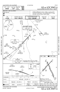
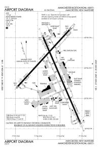
Runways:
| RWY identifier | QFU | Length (ft) | Width (ft) | Surface | LDA (ft) |
| 06 | 42° | 7651 | 150 | ASPH | 7208 |
| 24 | 222° | 7651 | 150 | ASPH | 6850 |
| 17 | 157° | 9250 | 150 | ASPH | 8914 |
| 35 | 337° | 9250 | 150 | ASPH | 7650 |
Airport contact information
Address: Manchester United States
