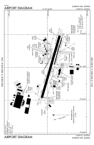


KMGE - Dobbins Arb
Located in Marietta, United States
ICAO - MGE, IATA - MGE
Data provided by AirmateGeneral information
Coordinates: N33°54'52" W84°30'51"
Elevation is 1068 feet MSL.
Magnetic variation is -03° East View others Airports in Georgia
Operational data
Special qualification required
Current time UTC:
Current local time:
Weather
METAR: KMGE 151955Z 25013G20KT 7SM FEW020TCU BKN060 BKN250 25/17 A2973 RMK AO2A TCU SE AND NW SLP060 T02540168
TAF: TAF KMGE 151302Z 1513/1619 25009KT 9999 BKN011 BKN085 QNH2975INS BECMG 1514/1515 26009KT 9999 SCT011 BKN085 QNH2974INS BECMG 1516/1517 27012G18KT 9999 VCSH SCT015 BKN050 BKN100 QNH2973INS TEMPO 1517/1521 29015G25KT 8000 -SHRA BR BKN020 OVC070 BECMG 1520/1521 30015G25KT 8000 -SHRA BR BKN020 OVC070 QNH2970INS BECMG 1523/1524 31007KT 9999 NSW SCT030 SCT080 QNH2975INS BECMG 1613/1614 34007KT 9999 FEW250 QNH2977INS TX27/1520Z TN16/1612Z
Communications frequencies: [VIEW]
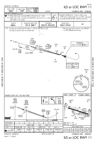
Runways:
| RWY identifier | QFU | Length (ft) | Width (ft) | Surface | LDA (ft) |
| 11 | 106° | 10002 | 300 | CONC | |
| 29 | 286° | 10002 | 300 | CONC | |
| 110 | 106° | 3495 | 60 | CONC | |
| 290 | 286° | 3495 | 60 | CONC |
Airport contact information
Address: Marietta United States