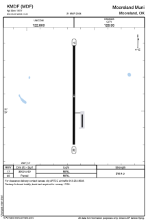


KMDF - Mooreland Muni
Located in Mooreland, United States
ICAO - MDF, IATA -
Data provided by AirmateGeneral information
Coordinates: N36°29'5" W99°11'39"
Elevation is 1970 feet MSL.
Magnetic variation is 08° East View others Airports in Oklahoma
Operational data
Special qualification required
Current time UTC:
Current local time:
Weather at : KWWR - West Woodward ( 30 km )
TAF: KWWR 091120Z 0912/1012 35004KT P6SM FEW250 FM091500 03010G18KT P6SM SCT150 FM100100 01006KT P6SM FEW250
Communications frequencies: [VIEW]
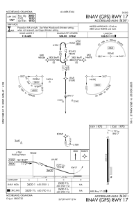
Runways:
| RWY identifier | QFU | Length (ft) | Width (ft) | Surface | LDA (ft) |
| 17 | 180° | 3500 | 60 | ASPH | |
| 35 | 0° | 3500 | 60 | ASPH |
Airport contact information
Address: Mooreland United States