


KMCW - Mason City Muni
Located in Mason City, United States
ICAO - MCW, IATA - MCW
Data provided by AirmateGeneral information
Coordinates: N43°9'28" W93°19'53"
Elevation is 1213 feet MSL.
Magnetic variation is 00° East View others Airports in Iowa
Operational data
Special qualification required
Current time UTC:
Current local time:
Weather
METAR: KMCW 271818Z AUTO 26015KT 10SM FEW022 OVC030 16/11 A2982 RMK AO2 T01610111
TAF: KMCW 271727Z 2718/2818 25012G20KT P6SM BKN020 FM272100 27009KT P6SM BKN035 FM280300 01009KT P6SM VCSH BKN030 FM280800 05010KT P6SM VCSH OVC020 FM281200 07012G21KT 6SM -SHRA BR OVC010
Communications frequencies: [VIEW]
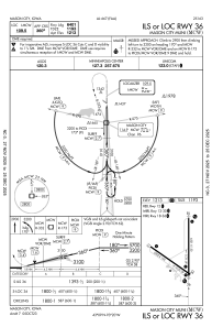
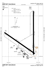
Runways:
| RWY identifier | QFU | Length (ft) | Width (ft) | Surface | LDA (ft) |
| 12 | 125° | 5502 | 150 | ASPH | 5501 |
| 30 | 305° | 5502 | 150 | ASPH | 5501 |
| 18 | 180° | 6501 | 150 | ASPH | 6501 |
| 36 | 360° | 6501 | 150 | ASPH | 6401 |
Airport contact information
Address: Mason City United States
