


KLXT - Lee's Summit Muni
Located in Lee's Summit, United States
ICAO - LXT, IATA -
Data provided by AirmateGeneral information
Coordinates: N38°57'33" W94°22'19"
Elevation is 1004 feet MSL.
Magnetic variation is 02° East View others Airports in Missouri
Operational data
Special qualification required
Current time UTC:
Current local time:
Weather
METAR: KLXT 270953Z AUTO 20009KT 10SM BKN030 20/17 A2973 RMK AO2 SLP059 T02000172
Communications frequencies: [VIEW]
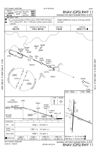
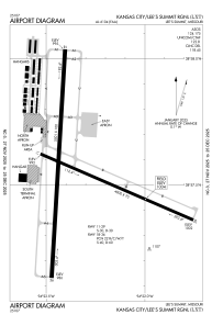
Runways:
| RWY identifier | QFU | Length (ft) | Width (ft) | Surface | LDA (ft) |
| 11 | 113° | 4000 | 75 | CONC | |
| 29 | 293° | 4000 | 75 | CONC | |
| 18 | 183° | 5501 | 100 | CONC | |
| 36 | 3° | 5501 | 100 | CONC |
Airport contact information
Address: Lee's Summit United States
