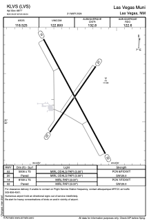


KLVS - Las Vegas Muni
Located in Las Vegas, United States
ICAO - LVS, IATA - LVS
Data provided by AirmateGeneral information
Coordinates: N35°39'15" W105°8'33"
Elevation is 6877 feet MSL.
Magnetic variation is 13° East View others Airports in New Mexico
Operational data
Special qualification required
Current time UTC:
Current local time:
Weather
METAR: KLVS 091553Z AUTO 09014G19KT 10SM BKN049 BKN095 12/M04 A3012 RMK AO2 SLP135 T01171039
TAF: KLVS 091130Z 0912/1012 04010KT P6SM BKN090 FM091400 07014G22KT P6SM BKN090 FM091900 10014G24KT P6SM BKN080 FM092200 13013G21KT P6SM VCSH BKN070 FM100200 05010G18KT P6SM VCSH OVC050 FM100600 02010KT P6SM VCSH OVC025
Communications frequencies: [VIEW]
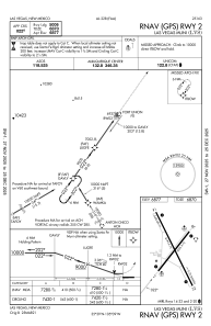
Runways:
| RWY identifier | QFU | Length (ft) | Width (ft) | Surface | LDA (ft) |
| 02 | 35° | 5006 | 75 | ASPH | |
| 20 | 215° | 5006 | 75 | ASPH | |
| 14 | 152° | 8199 | 75 | ASPH | |
| 32 | 332° | 8199 | 75 | ASPH |
Airport contact information
Address: Las Vegas United States