


KLSV - Nellis Afb
Located in Las Vegas, United States
ICAO - LSV, IATA - LSV
Data provided by AirmateGeneral information
Coordinates: N36°14'10" W115°2'3"
Elevation is 1869 feet MSL.
Magnetic variation is 12° East View others Airports in Nevada
Operational data
Special qualification required
Current time UTC:
Current local time:
Weather
METAR: KLSV 301555Z AUTO 07012KT 10SM CLR 25/M08 A2982 RMK AO2 SLP077 T02541085 $
TAF: TAF KLSV 301500Z 3015/0121 08010KT 9999 SKC QNH2970INS BECMG 3023/3024 22012G24KT 9999 SKC 510009 QNH2965INS BECMG 0106/0107 20010G18KT 9999 SKC QNH2968INS BECMG 0118/0119 34010KT 9999 SKC QNH2972INS TX32/0100Z TN19/0113Z
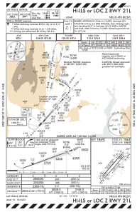
Communications frequencies: [VIEW]
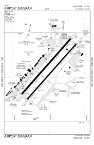
Runways:
| RWY identifier | QFU | Length (ft) | Width (ft) | Surface | LDA (ft) |
| 03L | 41° | 10120 | 200 | CONC | |
| 21R | 221° | 10120 | 200 | CONC | |
| 03R | 41° | 10051 | 150 | CONC | |
| 21L | 221° | 10051 | 150 | CONC | |
| H1 | 0° | 0 | 0 | UNK |
Airport contact information
Address: Las Vegas United States