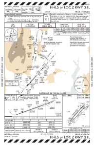
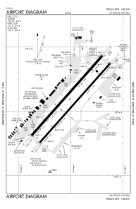


KLSV - Nellis Afb
Located in Las Vegas, United States
ICAO - LSV, IATA - LSV
Data provided by AirmateGeneral information
Coordinates: N36°14'10" W115°2'3"
Elevation is 1869 feet MSL.
Magnetic variation is 12° East View others Airports in Nevada
Operational data
Special qualification required
Current time UTC:
Current local time:
Weather
METAR: KLSV 262208Z AUTO 12004KT 10SM FEW026 FEW033 FEW150 14/09 A2966 RMK AO2 RAE08 SLPNO $
TAF: TAF KLSV 262300Z 2623/2805 01009KT 9999 VCSH SCT060 BKN070 QNH2959INS BECMG 2704/2705 30012KT 9999 VCSH SCT060 BKN080 QNH2966INS BECMG 2710/2711 33015G25KT 9999 NSW FEW100 SCT150 520009 QNH2973INS BECMG 2715/2716 31012G18KT 9999 FEW120 QNH2976INS TX26/2723Z TN13/2713Z
Communications frequencies: [VIEW]
Runways:
| RWY identifier | QFU | Length (ft) | Width (ft) | Surface | LDA (ft) |
| 03R | 41° | 10051 | 150 | CONC | |
| 21L | 221° | 10051 | 150 | CONC | |
| 03L | 41° | 10120 | 200 | CONC | |
| 21R | 221° | 10120 | 200 | CONC |
Airport contact information
Address: Las Vegas United States