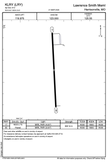


KLRY - Lawrence Smith Meml
Located in Harrisonville, United States
ICAO - LRY, IATA -
Data provided by AirmateGeneral information
Coordinates: N38°36'37" W94°20'37"
Elevation is 915 feet MSL.
Magnetic variation is 04° East View others Airports in Missouri
Operational data
Special qualification required
Current time UTC:
Current local time:
Weather
METAR: KLRY 021235Z AUTO 19010KT 10SM VCTS BKN065 BKN080 BKN100 21/17 A2978 RMK AO2 LTG DSNT W THRU N
Communications frequencies: [VIEW]
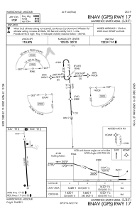
Runways:
| RWY identifier | QFU | Length (ft) | Width (ft) | Surface | LDA (ft) |
| 17 | 177° | 4000 | 75 | ASPH | 4000 |
| 35 | 357° | 4000 | 75 | ASPH | 4000 |
Airport contact information
Address: Harrisonville United States