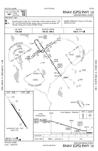
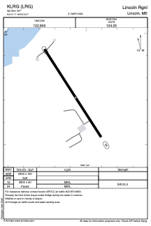


KLRG - Lincoln Rgnl
Located in Lincoln, United States
ICAO - LRG, IATA -
Data provided by AirmateGeneral information
Coordinates: N45°21'43" W68°32'4"
Elevation is 207 feet MSL.
Magnetic variation is -19° East View others Airports in Maine
Operational data
Special qualification required
Current time UTC:
Current local time:
Weather at : KMLT - Millinocket Muni ( 34 km )
METAR: KMLT 152353Z AUTO 00000KT 10SM FEW055 SCT085 BKN120 17/14 A2984 RMK AO2 RAE47 SLP111 P0006 60030 T01670139 10261 20161 51016
Communications frequencies: [VIEW]
Runways:
| RWY identifier | QFU | Length (ft) | Width (ft) | Surface | LDA (ft) |
| 06W | 0° | 2400 | 100 | WATER | |
| 24W | 0° | 2400 | 100 | WATER | |
| 16 | 147° | 2805 | 60 | ASPH | |
| 34 | 327° | 2805 | 60 | ASPH |
Airport contact information
Address: Lincoln United States