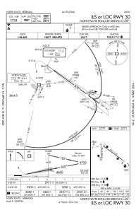
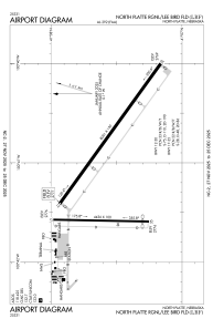


KLBF - North Platte Rgnl/Lee Bird Fld
Located in North Platte, United States
ICAO - LBF, IATA - LBF
Data provided by AirmateGeneral information
Coordinates: N41°7'34" W100°41'1"
Elevation is 2777 feet MSL.
Magnetic variation is 06° East View others Airports in Nebraska
Operational data
Special qualification required
Current time UTC:
Current local time:
Weather
METAR: KLBF 272353Z AUTO 03014G23KT 10SM OVC023 11/06 A2985 RMK AO2 SLP109 T01060056 10139 20106 51021
TAF: KLBF 272320Z 2800/2824 03015KT P6SM VCSH OVC025 FM280300 03015KT 4SM SHRA BR OVC015 FM280600 02015KT 5SM SHRA BR VCTS OVC008CB FM280900 01013KT 5SM SHRA BR OVC006 FM281300 35013KT 3SM SHRA BR OVC005 FM282200 33013KT P6SM BKN017
Communications frequencies: [VIEW]
Runways:
| RWY identifier | QFU | Length (ft) | Width (ft) | Surface | LDA (ft) |
| 12 | 126° | 8001 | 150 | CONC | 8000 |
| 30 | 306° | 8001 | 150 | CONC | 8000 |
| 17 | 181° | 4436 | 100 | CONC | 4135 |
| 35 | 1° | 4436 | 100 | CONC | 4135 |
Airport contact information
Address: North Platte United States