


KLAW - Lawton-Fort Sill Rgnl
Located in Lawton, United States
ICAO - LAW, IATA - LAW
Data provided by AirmateGeneral information
Coordinates: N34°34'4" W98°24'60"
Elevation is 1110 feet MSL.
Magnetic variation is 06° East View others Airports in Oklahoma
Operational data
Special qualification required
Current time UTC:
Current local time:
Weather
METAR: KLAW 271453Z 15010KT 7SM FEW014 BKN021 OVC038 23/21 A2975 RMK AO2 SLP064 T02330206 50007
TAF: KLAW 271121Z 2712/2812 16012G18KT P6SM BKN015 FM272000 16018G29KT P6SM -SHRA BKN035 PROB30 2720/2722 2SM +TSRA OVC015CB FM272200 17018G29KT 5SM -TSRA OVC045CB TEMPO 2722/2802 2SM +TSRA OVC015CB FM280200 15010KT P6SM OVC250 PROB30 2802/2805 P6SM -TSRA BKN050CB FM280900 17005KT P6SM -SHRA OVC250 PROB30 2809/2811 P6SM -TSRA BKN050CB
Communications frequencies: [VIEW]
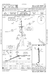
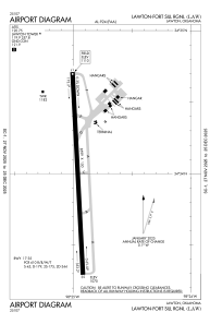
Runways:
| RWY identifier | QFU | Length (ft) | Width (ft) | Surface | LDA (ft) |
| 17 | 177° | 8599 | 150 | CONC | 8599 |
| 35 | 357° | 8599 | 150 | CONC | 8599 |
Airport contact information
Address: Lawton United States
