


KJXN - Jackson County/Reynolds Fld
Located in Jackson, United States
ICAO - JXN, IATA - JXN
Data provided by AirmateGeneral information
Coordinates: N42°15'38" W84°27'44"
Elevation is 1000 feet MSL.
Magnetic variation is -07° East View others Airports in Michigan
Operational data
Special qualification required
Current time UTC:
Current local time:
Weather
METAR: KJXN 290856Z AUTO 18007KT 10SM SCT120 19/15 A2991 RMK AO2 SLP123 T01890150 57010
TAF: KJXN 290550Z 2906/3006 19007KT P6SM BKN250 FM291600 19016G25KT P6SM BKN035 BKN060 FM291800 22015G24KT P6SM -SHRA BKN035 OVC060 FM292000 22015KT P6SM -SHRA BKN045 BKN050 FM292100 22014KT P6SM BKN045 OVC050
Communications frequencies: [VIEW]
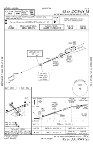
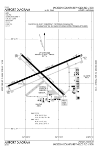
Runways:
| RWY identifier | QFU | Length (ft) | Width (ft) | Surface | LDA (ft) |
| 14 | 133° | 4000 | 100 | ASPH | |
| 32 | 313° | 4000 | 100 | ASPH | |
| 07 | 67° | 5351 | 100 | ASPH | |
| 25 | 247° | 5351 | 100 | ASPH |
Airport contact information
Address: Jackson United States