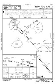
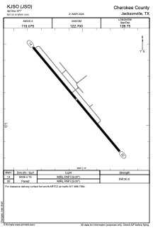


KJSO - Cherokee County
Located in Jacksonville, United States
ICAO - JSO, IATA - JKV
Data provided by AirmateGeneral information
Coordinates: N31°52'10" W95°13'3"
Elevation is 677 feet MSL.
Magnetic variation is 05° East View others Airports in Texas
Operational data
Special qualification required
Current time UTC:
Current local time:
Weather
METAR: KJSO 011415Z AUTO 18008KT 10SM CLR 23/19 A2995 RMK AO2 T02260192
Communications frequencies: [VIEW]
Runways:
| RWY identifier | QFU | Length (ft) | Width (ft) | Surface | LDA (ft) |
| 14 | 140° | 5006 | 75 | ASPH | |
| 32 | 320° | 5006 | 75 | ASPH |
Airport contact information
Address: Jacksonville United States
