


KJMS - Jamestown Rgnl
Located in Jamestown, United States
ICAO - JMS, IATA - JMS
Data provided by AirmateGeneral information
Coordinates: N46°55'47" W98°40'41"
Elevation is 1499 feet MSL.
Magnetic variation is 04° East View others Airports in North Dakota
Operational data
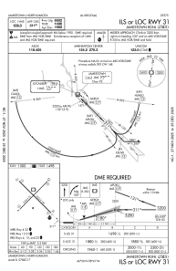
Special qualification required
Current time UTC:
Current local time:
Weather
METAR: KJMS 271056Z AUTO 36015KT 10SM OVC014 07/05 A2969 RMK AO2 SLP061 T00720050 $
TAF: KJMS 270927Z 2709/2806 01011KT P6SM VCSH OVC006 TEMPO 2709/2712 6SM -SHRA BKN004 OVC009 FM271200 36018G26KT P6SM VCSH OVC005 FM271600 36018G27KT P6SM OVC006 FM272000 01018G27KT P6SM OVC011 FM280000 02015G23KT P6SM BKN015
Communications frequencies: [VIEW]
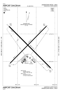
Runways:
| RWY identifier | QFU | Length (ft) | Width (ft) | Surface | LDA (ft) |
| 04 | 45° | 5750 | 75 | ASPH | 5750 |
| 22 | 225° | 5750 | 75 | ASPH | 5750 |
| 13 | 135° | 6502 | 100 | ASPH | 6502 |
| 31 | 315° | 6502 | 100 | ASPH | 6502 |
Airport contact information
Address: Jamestown United States