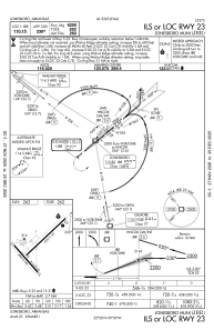
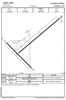


KJBR - Jonesboro Muni
Located in Jonesboro, United States
ICAO - JBR, IATA - JBR
Data provided by AirmateGeneral information
Coordinates: N35°49'54" W90°38'47"
Elevation is 262 feet MSL.
Magnetic variation is -00° East View others Airports in Arkansas
Operational data
Special qualification required
Current time UTC:
Current local time:
Weather
METAR: KJBR 032153Z AUTO VRB04KT 10SM SCT019 OVC100 23/19 A2994 RMK AO2 SLP134 T02330189 $
TAF: KJBR 031722Z 0318/0418 26005KT P6SM VCSH BKN025 TEMPO 0318/0320 5SM -SHRA SCT007 OVC025 FM032100 VRB03KT P6SM BKN035 FM040300 00000KT 6SM BR BKN200 TEMPO 0408/0412 3SM BR SCT003 FM041500 24006KT P6SM BKN035
Communications frequencies: [VIEW]
Runways:
| RWY identifier | QFU | Length (ft) | Width (ft) | Surface | LDA (ft) |
| 05 | 50° | 6200 | 150 | ASPH | |
| 23 | 230° | 6200 | 150 | ASPH | |
| 13 | 135° | 4099 | 150 | ASPH | |
| 31 | 315° | 4099 | 150 | ASPH |
Airport contact information
Address: Jonesboro United States
