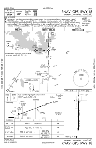
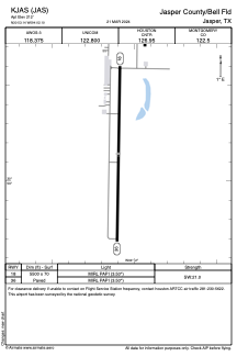


KJAS - Jasper County/Bell Fld
Located in Jasper, United States
ICAO - JAS, IATA - JAS
Data provided by AirmateGeneral information
Coordinates: N30°53'8" W94°2'6"
Elevation is 212 feet MSL.
Magnetic variation is 04° East View others Airports in Texas
Operational data
Special qualification required
Current time UTC:
Current local time:
Weather
METAR: KJAS 290755Z AUTO 02008KT 1 3/4SM VCTS RA BR BKN004 OVC032 18/18 A2986 RMK AO2 P0025
Communications frequencies: [VIEW]
Runways:
| RWY identifier | QFU | Length (ft) | Width (ft) | Surface | LDA (ft) |
| 18 | 181° | 5500 | 70 | ASPH | |
| 36 | 1° | 5500 | 70 | ASPH |
Airport contact information
Address: Jasper United States