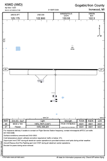


KIWD - Gogebic/Iron County
Located in Ironwood, United States
ICAO - IWD, IATA - IWD
Data provided by AirmateGeneral information
Coordinates: N46°31'39" W90°7'53"
Elevation is 1230 feet MSL.
Magnetic variation is 00° East View others Airports in Michigan
Operational data
Special qualification required
Current time UTC:
Current local time:
Weather
METAR: KIWD 271356Z AUTO 18007G15KT 10SM BKN010 13/12 A2950 RMK AO2 SLP993 T01280117
TAF: KIWD 271140Z 2712/2812 15010KT P6SM VCSH SCT008 BKN014 WS020/19045KT FM271300 16010G18KT P6SM VCSH SCT008 BKN014 FM271600 20012G22KT P6SM VCSH BKN009 FM271800 23013G24KT 6SM -SHRA BR OVC005 FM272100 27012G20KT 5SM BR VCSH OVC005 FM272300 29010KT P6SM OVC006 FM280900 06008KT P6SM BKN005
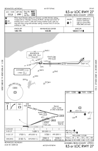
Communications frequencies: [VIEW]
Runways:
| RWY identifier | QFU | Length (ft) | Width (ft) | Surface | LDA (ft) |
| 09 | 90° | 6502 | 100 | ASPH | 6501 |
| 27 | 270° | 6502 | 100 | ASPH | 6501 |
Airport contact information
Address: Ironwood United States