


KIPL - Imperial County
Located in Imperial, United States
ICAO - IPL, IATA - IPL
Data provided by AirmateGeneral information
Coordinates: N32°50'3" W115°34'44"
Elevation is -53 feet MSL.
Magnetic variation is 14° East View others Airports in California
Operational data
Special qualification required
Current time UTC:
Current local time:
Weather
METAR: KIPL 282353Z AUTO VRB06KT 10SM CLR 31/02 A2980 RMK AO2 SLP091 T03110017 10317 20261 56022 PWINO $
TAF: KIPL 282320Z 2900/2924 VRB04KT P6SM SKC FM290400 24006KT P6SM SKC FM291300 VRB04KT P6SM SKC FM292000 12009KT P6SM SKC
Communications frequencies: [VIEW]
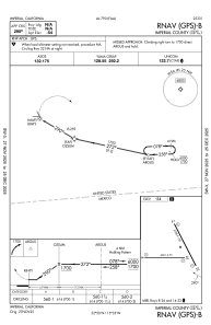
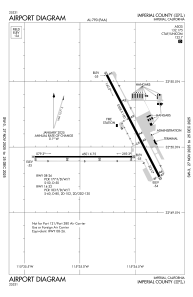
Runways:
| RWY identifier | QFU | Length (ft) | Width (ft) | Surface | LDA (ft) |
| 08 | 90° | 4501 | 75 | ASPH | 4501 |
| 26 | 270° | 4501 | 75 | ASPH | 4501 |
| 14 | 153° | 5308 | 100 | ASPH | 5304 |
| 32 | 333° | 5308 | 100 | ASPH | 5304 |
Airport contact information
Address: Imperial United States
