


KINS - Creech Afb
Situé à Indian Springs, United States
ICAO - INS, IATA - INS
Données fournies par AirmateInformation générale
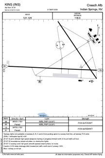
Coordonnées: N36°35'11" W115°40'39"
Élévation : 3134 feet MSL.
Variation magnétique : 15° East Voir autres Aéroports à Nevada
Données opérationnelles
Special qualification required
Heure actuelle UTC:
Heure actuelle locale:
Météo
METAR: KINS 030455Z AUTO 27006KT 10SM CLR 19/M16 A2980 RMK AO2 SLP054 T01921159 $
TAF: TAF KINS 030456Z 0305/0411 VRB06KT 9999 SKC QNH2980INS BECMG 0317/0318 01009KT 9999 FEW130 QNH2976INS BECMG 0321/0322 33010G15KT 9999 FEW120 QNH2970INS BECMG 0403/0404 25009KT 9999 FEW150 QNH2975INS BECMG 0405/0406 VRB06KT 9999 FEW180 QNH2976INS TX28/0323Z TN11/0313Z
Fréquences de communication: [VIEW]
Pistes:
| Identifiant RWY | QFU | Longueur (ft) | Largeur (ft) | Surface | LDA (ft) |
| 08 | 93° | 9002 | 150 | ASPH | |
| 26 | 273° | 9002 | 150 | ASPH | |
| 13 | 0° | 5476 | 100 | ASPH | |
| 31 | 0° | 5476 | 100 | ASPH |
Coordonnées de l'aéroport
Adresse: Indian Springs United States