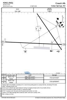


KINS - Creech Afb
Located in Indian Springs, United States
ICAO - INS, IATA - INS
Data provided by AirmateGeneral information
Coordinates: N36°35'11" W115°40'39"
Elevation is 3134 feet MSL.
Magnetic variation is 15° East View others Airports in Nevada
Operational data
Special qualification required
Current time UTC:
Current local time:
Weather
METAR: KINS 281055Z AUTO 25004KT 10SM CLR 12/M02 A2997 RMK AO2 SLP118 T01231024 $
Communications frequencies: [VIEW]
Runways:
| RWY identifier | QFU | Length (ft) | Width (ft) | Surface | LDA (ft) |
| 08 | 93° | 9002 | 150 | ASPH | |
| 26 | 273° | 9002 | 150 | ASPH | |
| 13 | 0° | 5476 | 100 | ASPH | |
| 31 | 0° | 5476 | 100 | ASPH |
Airport contact information
Address: Indian Springs United States