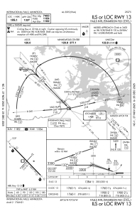
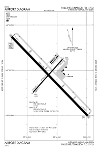


KINL - Falls Intl/Einarson Fld
Located in International Falls, United States
ICAO - INL, IATA - INL
Data provided by AirmateGeneral information
Coordinates: N48°33'56" W93°24'8"
Elevation is 1184 feet MSL.
Magnetic variation is 03° East View others Airports in Minnesota
Operational data
Special qualification required
Current time UTC:
Current local time:
Weather
METAR: KINL 271154Z AUTO 05007KT 4SM RA BR OVC004 06/05 A2962 RMK AO2 SLP039 P0006 60015 70035 T00560050 10067 20056 55003
TAF: KINL 271127Z 2712/2812 03007KT 3SM SHRA BR OVC003 FM271500 36009KT 2SM SHRA BR OVC003 FM271800 35011G20KT P6SM VCSH OVC005 FM272200 01009G17KT P6SM OVC009 FM280200 02009KT P6SM BKN013 FM280800 05007KT P6SM BKN010
Communications frequencies: [VIEW]
Runways:
| RWY identifier | QFU | Length (ft) | Width (ft) | Surface | LDA (ft) |
| 04 | 42° | 2999 | 75 | ASPH | 2999 |
| 22 | 222° | 2999 | 75 | ASPH | 2999 |
| 13 | 136° | 7400 | 150 | ASPH | 7400 |
| 31 | 316° | 7400 | 150 | ASPH | 7400 |
Airport contact information
Address: International Falls United States