


KIFP - Laughlin/Bullhead Intl
Located in Bullhead City, United States
ICAO - IFP, IATA - IFP
Data provided by AirmateGeneral information
Coordinates: N35°9'17" W114°33'34"
Elevation is 707 feet MSL.
Magnetic variation is 12° East View others Airports in Arizona
Operational data
Special qualification required
Current time UTC:
Current local time:
Weather
METAR: KIFP 280915Z AUTO 00000KT 10SM CLR 20/M01 A2987 RMK AO2
TAF: KIFP 280520Z 2806/2906 33008KT P6SM SCT200 FM281700 02011KT P6SM FEW140 FM290200 16007KT P6SM SKC
Communications frequencies: [VIEW]
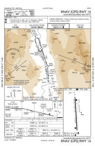
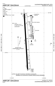
Runways:
| RWY identifier | QFU | Length (ft) | Width (ft) | Surface | LDA (ft) |
| 16 | 176° | 8501 | 150 | ASPH | 8500 |
| 34 | 356° | 8501 | 150 | ASPH | 8500 |
Airport contact information
Address: Bullhead City United States