


KIDP - Independence Muni
Located in Independence, United States
ICAO - IDP, IATA - IDP
Data provided by AirmateGeneral information
Coordinates: N37°9'29" W95°46'44"
Elevation is 824 feet MSL.
Magnetic variation is 02° East View others Airports in Kansas
Operational data
Special qualification required
Current time UTC:
Current local time:
Weather
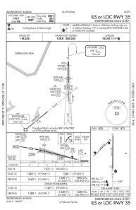
METAR: KIDP 280635Z AUTO 24007KT 10SM TSRA SCT070 OVC100 17/15 A2973 RMK AO2 LTG DSNT ALQDS P0010 T01720153
Communications frequencies: [VIEW]
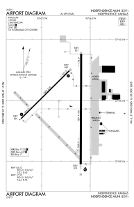
Runways:
| RWY identifier | QFU | Length (ft) | Width (ft) | Surface | LDA (ft) |
| 04 | 45° | 3402 | 60 | ASPH | |
| 22 | 225° | 3402 | 60 | ASPH | |
| 17 | 180° | 5501 | 100 | ASPH | |
| 35 | 0° | 5501 | 100 | ASPH |
Airport contact information
Address: Independence United States