


KIDA - Idaho Falls Rgnl
Located in Idaho Falls, United States
ICAO - IDA, IATA - IDA
Data provided by AirmateGeneral information
Coordinates: N43°30'49" W112°4'15"
Elevation is 4743 feet MSL.
Magnetic variation is 12° East View others Airports in Idaho
Operational data
Special qualification required
Current time UTC:
Current local time:
Weather
METAR: KIDA 291853Z 24018G29KT 10SM BKN100 14/01 A2983 RMK AO2 PK WND 22036/1835 SLP084 T01440006
TAF: KIDA 291725Z 2918/3018 22015G25KT P6SM SCT070 SCT100 FM292000 23025G35KT P6SM VCSH SCT060 BKN080 FM300100 24020G30KT P6SM SCT060 BKN100 FM300500 22015KT P6SM FEW060 FM301500 23020KT P6SM SCT100
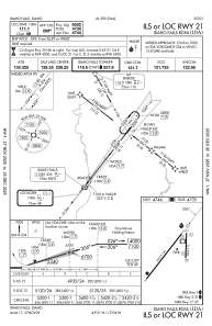
Communications frequencies: [VIEW]
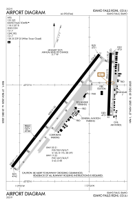
Runways:
| RWY identifier | QFU | Length (ft) | Width (ft) | Surface | LDA (ft) |
| 03 | 38° | 9002 | 150 | ASPH | 9002 |
| 21 | 218° | 9002 | 150 | ASPH | 9002 |
| 17 | 182° | 3964 | 75 | ASPH | |
| 35 | 2° | 3964 | 75 | ASPH |
Airport contact information
Address: Idaho Falls United States

