


KIAH - George Bush Intcntl/Houston
Located in Houston, United States
ICAO - IAH, IATA - IAH
Data provided by AirmateGeneral information
Coordinates: N29°59'4" W95°20'29"
Elevation is 95 feet MSL.
Magnetic variation is 03° East View others Airports in Texas
Operational data
Special qualification required
Current time UTC:
Current local time:
Weather
METAR: KIAH 281053Z 14019G24KT 7SM SCT025 24/20 A2981 RMK AO2 PK WND 15027/0955 SLP095 T02390200
TAF: KIAH 281120Z 2812/2918 14015G25KT P6SM SCT025 FM281800 15016G26KT P6SM VCSH OVC040 FM282200 14014G24KT P6SM VCTS SCT015 BKN025CB FM290200 16013KT P6SM VCTS SCT009 OVC012CB TEMPO 2903/2907 VRB25KT 3SM TSRA FM290900 16010KT 6SM BR SCT015 BKN020 FM291200 22009KT P6SM OVC015
Communications frequencies: [VIEW]
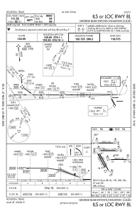
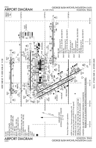
Runways:
| RWY identifier | QFU | Length (ft) | Width (ft) | Surface | LDA (ft) |
| 08R | 90° | 9402 | 150 | CONC | 9402 |
| 26L | 270° | 9402 | 150 | CONC | 9402 |
| 08L | 90° | 9000 | 150 | CONC | 9000 |
| 26R | 270° | 9000 | 150 | CONC | 9000 |
| 09 | 90° | 10000 | 150 | CONC | 10000 |
| 27 | 270° | 10000 | 150 | CONC | 10000 |
| 15R | 152° | 10000 | 150 | CONC | 9999 |
| 33L | 332° | 10000 | 150 | CONC | 9999 |
| 15L | 152° | 12001 | 150 | CONC | 12001 |
| 33R | 332° | 12001 | 150 | CONC | 12001 |
Airport contact information
Address: Houston United States