


KHUT - Hutchinson Rgnl
Located in Hutchinson, United States
ICAO - HUT, IATA - HUT
Data provided by AirmateGeneral information
Coordinates: N38°3'58" W97°51'38"
Elevation is 1542 feet MSL.
Magnetic variation is 04° East View others Airports in Kansas
Operational data
Special qualification required
Current time UTC:
Current local time:
Weather
METAR: KHUT 261109Z 08012KT 10SM SCT029 18/14 A2954 RMK AO2 T01780139
TAF: KHUT 261120Z 2612/2712 08009KT P6SM BKN030 FM261400 03011KT P6SM SCT060 FM261900 33013KT P6SM SCT100 FM270100 34009KT P6SM FEW200
Communications frequencies: [VIEW]
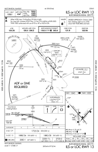
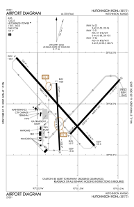
Runways:
| RWY identifier | QFU | Length (ft) | Width (ft) | Surface | LDA (ft) |
| 04 | 42° | 4405 | 100 | ASPH | 4401 |
| 22 | 222° | 4405 | 100 | ASPH | 4401 |
| 13 | 138° | 7003 | 100 | ASPH | 7003 |
| 31 | 318° | 7003 | 100 | ASPH | 7003 |
| 17 | 177° | 4012 | 75 | CONC | 4012 |
| 35 | 357° | 4012 | 75 | CONC | 4012 |
Airport contact information
Address: Hutchinson United States
