


KHUM - Houma-Terrebonne
Located in Houma, United States
ICAO - HUM, IATA - HUM
Data provided by AirmateGeneral information
Coordinates: N29°33'59" W90°39'38"
Elevation is 9 feet MSL.
Magnetic variation is 01° East View others Airports in Louisiana
Operational data
Special qualification required
Current time UTC:
Current local time:
Weather
METAR: KHUM 140655Z AUTO 17007G19KT 5SM BR CLR 22/21 A2975 RMK AO2 T02200206
TAF: KHUM 140522Z 1406/1506 05009KT P6SM -RA BKN012 BKN030 FM141000 VRB04KT 5SM BR BKN010 FM141400 22007KT P6SM BKN020 FM141700 19010KT P6SM BKN025 FM150100 VRB04KT P6SM SKC
Communications frequencies: [VIEW]
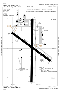
Runways:
| RWY identifier | QFU | Length (ft) | Width (ft) | Surface | LDA (ft) |
| 12 | 125° | 4999 | 185 | CONC | |
| 30 | 305° | 4999 | 185 | CONC | |
| 18 | 180° | 6508 | 150 | CONC | |
| 36 | 0° | 6508 | 150 | CONC |
Airport contact information
Address: Houma United States


