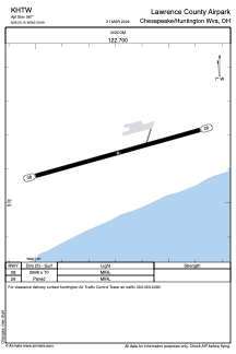


KHTW - Lawrence County Airpark
Located in Chesapeake/Huntington Wva, United States
ICAO - HTW, IATA -
Data provided by AirmateGeneral information
Coordinates: N38°25'9" W82°29'41"
Elevation is 567 feet MSL.
Magnetic variation is -05° East View others Airports in Ohio
Operational data
Special qualification required
Current time UTC:
Current local time:
Weather at : KHTS - Tri-State/Milton J Ferguson Fld ( 8 km )
METAR: KHTS 150951Z 00000KT 10SM FEW030 FEW049 OVC060 18/16 A2965 RMK AO2 RAE24 SLP035 P0008 T01780161
TAF: KHTS 150829Z 1508/1606 VRB03KT P6SM VCSH SCT003 OVC040 TEMPO 1509/1510 -SHRA OVC003 FM151000 00000KT 4SM BR VCSH OVC003 FM151100 00000KT 1/4SM FG OVC001 FM151200 22003KT 1SM BR OVC009 TEMPO 1512/1515 -SHRA OVC003 FM151500 22003KT 6SM -SHRA BR VCTS OVC015CB
Communications frequencies: [VIEW]
Runways:
| RWY identifier | QFU | Length (ft) | Width (ft) | Surface | LDA (ft) |
| 08 | 75° | 2998 | 70 | ASPH | |
| 26 | 255° | 2998 | 70 | ASPH |
Airport contact information
Address: Chesapeake/Huntington Wva United States