


KHON - Huron Rgnl
Located in Huron, United States
ICAO - HON, IATA - HON
Data provided by AirmateGeneral information
Coordinates: N44°23'7" W98°13'43"
Elevation is 1288 feet MSL.
Magnetic variation is 07° East View others Airports in South Dakota
Operational data
Special qualification required
Current time UTC:
Current local time:
Weather
METAR: KHON 272155Z AUTO 02013G21KT 10SM OVC018 10/07 A2989 RMK AO2 SLP126 T01000067
TAF: KHON 272106Z 2721/2818 35014G18KT P6SM OVC025 FM272200 36013G19KT P6SM OVC012 FM280000 02011G18KT P6SM OVC015 FM281200 03013G20KT 5SM -RA OVC009 FM281500 03016G25KT 2SM -RA OVC007
Communications frequencies: [VIEW]
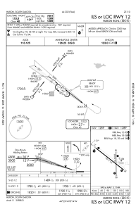
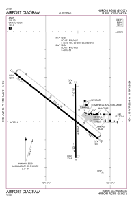
Runways:
| RWY identifier | QFU | Length (ft) | Width (ft) | Surface | LDA (ft) |
| 12 | 128° | 7201 | 100 | CONC | 7201 |
| 30 | 308° | 7201 | 100 | CONC | 7201 |
| 18 | 180° | 5000 | 75 | CONC | 5000 |
| 36 | 360° | 5000 | 75 | CONC | 5000 |
Airport contact information
Address: Huron United States
