


KHIB - Range Rgnl
Located in Hibbing, United States
ICAO - HIB, IATA - HIB
Data provided by AirmateGeneral information
Coordinates: N47°23'12" W92°50'20"
Elevation is 1353 feet MSL.
Magnetic variation is 02° East View others Airports in Minnesota
Operational data
Special qualification required
Current time UTC:
Current local time:
Weather
METAR: KHIB 172053Z AUTO 13011KT 10SM CLR 22/08 A2959 RMK AO2 SLP024 60001 T02170083 58014
TAF: KHIB 171739Z 1718/1818 13008KT P6SM VCSH BKN090 FM172000 17009G17KT P6SM BKN100 FM180400 13007G15KT 6SM -SHRA BR VCTS BKN030 BKN090CB WS020/19035KT FM181400 18011G22KT P6SM SCT025
Communications frequencies: [VIEW]
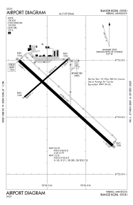
Runways:
| RWY identifier | QFU | Length (ft) | Width (ft) | Surface | LDA (ft) |
| 04 | 49° | 3075 | 75 | ASPH | 3075 |
| 22 | 229° | 3075 | 75 | ASPH | 3075 |
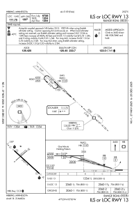
| 13 | 132° | 6758 | 150 | ASPH | 6758 |
| 31 | 312° | 6758 | 150 | ASPH | 6758 |
Airport contact information
Address: Hibbing United States