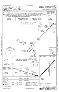
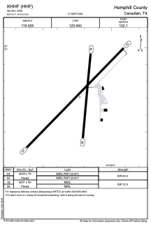


KHHF - Hemphill County
Located in Canadian, United States
ICAO - HHF, IATA -
Data provided by AirmateGeneral information
Coordinates: N35°53'42" W100°24'14"
Elevation is 2396 feet MSL.
Magnetic variation is 06° East View others Airports in Texas
Operational data
Special qualification required
Current time UTC:
Current local time:
Weather
METAR: KHHF 160015Z AUTO 00000KT 2 1/2SM -TSRA SCT019 BKN060 OVC090 16/13 A2976 RMK AO2 VIS 1V5 LTG DSNT ALQS P0024 T01600126
Communications frequencies: [VIEW]
Runways:
| RWY identifier | QFU | Length (ft) | Width (ft) | Surface | LDA (ft) |
| 04 | 44° | 5004 | 75 | ASPH | |
| 22 | 224° | 5004 | 75 | ASPH | |
| 18 | 185° | 3001 | 60 | ASPH | |
| 36 | 5° | 3001 | 60 | ASPH |
Airport contact information
Address: Canadian United States
