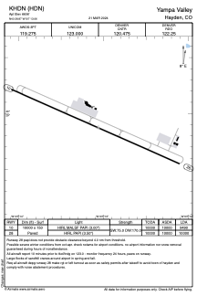


KHDN - Yampa Valley
Located in Hayden, United States
ICAO - HDN, IATA - HDN
Data provided by AirmateGeneral information
Coordinates: N40°28'52" W107°13'4"
Elevation is 6606 feet MSL.
Magnetic variation is 10° East View others Airports in Colorado
Operational data
Special qualification required
Current time UTC:
Current local time:
Weather
METAR: KHDN 270556Z AUTO 08014KT 10SM OVC085 04/04 A2976 RMK AO2 SLP045 60005 T00440039 10061 20039 401170039 56005
TAF: KHDN 270524Z 2706/2806 10009KT P6SM OVC090 FM270900 11006KT P6SM VCSH OVC050 FM271400 12006KT 6SM -RA BR OVC025 FM272200 10008KT 6SM -RA OVC050 FM280300 13007KT 4SM -RA OVC050
Communications frequencies: [VIEW]
Runways:
| RWY identifier | QFU | Length (ft) | Width (ft) | Surface | LDA (ft) |
| 10 | 114° | 10000 | 150 | ASPH | 9490 |
| 28 | 294° | 10000 | 150 | ASPH | 10000 |
Airport contact information
Address: Hayden United States