


KGUR - Camp Guernsey
Located in Guernsey, United States
ICAO - GUR, IATA -
Data provided by AirmateGeneral information
Coordinates: N42°15'35" W104°43'42"
Elevation is 4401 feet MSL.
Magnetic variation is 11° East View others Airports in Wyoming
Operational data
Special qualification required
Current time UTC:
Current local time:
Weather
METAR: KGUR 082255Z AUTO 32021G25KT 8SM OVC055 12/01 A2979 RMK AO2 SLP097 T01170008
TAF: TAF KGUR 082100Z 0821/1003 31015G25KT 9999 OVC050 620702 510003 QNH2975INS BECMG 0903/0904 34009KT 8000 -RA BKN015 620406 QNH2990INS BECMG 0908/0909 03009KT 9999 NSW BKN025 620405 QNH3004INS TEMPO 0911/0914 8000 -RA BKN015 BECMG 0917/0918 01010G15KT 8000 -RA BKN015 620402 QNH3020INS BECMG 1001/1002 01009KT 9999 NSW BKN050 QNH3024INS TX13/0821Z TN05/0910Z
Communications frequencies: [VIEW]
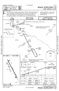
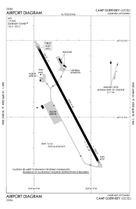
Runways:
| RWY identifier | QFU | Length (ft) | Width (ft) | Surface | LDA (ft) |
| 14 | 152° | 5060 | 90 | ASPH | |
| 32 | 332° | 5060 | 90 | ASPH |
Airport contact information
Address: Guernsey United States