


KGRR - Gerald R Ford Intl
Located in Grand Rapids, United States
ICAO - GRR, IATA - GRR
Data provided by AirmateGeneral information
Coordinates: N42°52'51" W85°31'22"
Elevation is 793 feet MSL.
Magnetic variation is -06° East View others Airports in Michigan
Operational data
Special qualification required
Current time UTC:
Current local time:
Weather
METAR: KGRR 280353Z 20012G21KT 10SM FEW047 OVC250 21/16 A2994 RMK AO2 SLP134 LAST T02060161 $
TAF: KGRR 272340Z 2800/2824 22013G27KT P6SM BKN050 FM280700 22011G24KT 4SM SHRA BKN040 FM281000 22006KT 2SM -RA BR OVC006 FM281500 21007KT 4SM -SHRA BR OVC012 FM282100 16010KT 5SM BR VCSH OVC030 FM282300 13009KT P6SM VCSH OVC050
Communications frequencies: [VIEW]
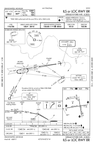
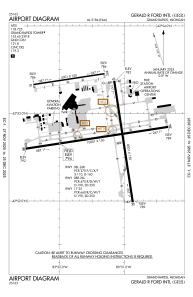
Runways:
| RWY identifier | QFU | Length (ft) | Width (ft) | Surface | LDA (ft) |
| 08R | 81° | 10001 | 150 | CONC | 10001 |
| 26L | 261° | 10001 | 150 | CONC | 10001 |
| 08L | 81° | 5001 | 100 | ASPH | 5001 |
| 26R | 261° | 5001 | 100 | ASPH | 5001 |
| 17 | 171° | 8501 | 150 | CONC | 8501 |
| 35 | 351° | 8501 | 150 | CONC | 8501 |
Airport contact information
Address: Grand Rapids United States
