


KGKY - Arlington Muni
Located in Arlington, United States
ICAO - GKY, IATA -
Data provided by AirmateGeneral information
Coordinates: N32°39'50" W97°5'39"
Elevation is 628 feet MSL.
Magnetic variation is 06° East View others Airports in Texas
Operational data
Special qualification required
Current time UTC:
Current local time:
Weather
METAR: KGKY 020053Z 13008KT 10SM FEW033 BKN050 BKN085 26/21 A2975 RMK AO2 SLP064 T02560206
Communications frequencies: [VIEW]
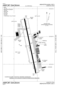
Runways:
| RWY identifier | QFU | Length (ft) | Width (ft) | Surface | LDA (ft) |
| 16 | 168° | 6080 | 100 | CONC | |
| 34 | 348° | 6080 | 100 | CONC |
Airport contact information
Address: Arlington United States
