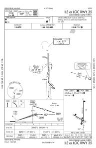
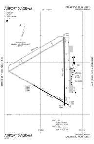


KGBD - Great Bend Muni
Located in Great Bend, United States
ICAO - GBD, IATA - GBD
Data provided by AirmateGeneral information
Coordinates: N38°20'39" W98°51'33"
Elevation is 1886 feet MSL.
Magnetic variation is 08° East View others Airports in Kansas
Operational data
Special qualification required
Current time UTC:
Current local time:
Weather
METAR: KGBD 060056Z AUTO 16016G25KT 10SM CLR 19/14 A2983 RMK AO2 SLP096 T01890139
TAF: KGBD 052326Z 0600/0624 15016KT P6SM FEW035 OVC050 FM060500 15016KT P6SM BKN009 FM061300 16018G28KT P6SM OVC040 FM061600 17023G33KT P6SM OVC025 FM061800 18023G33KT P6SM BKN035 PROB30 0620/0623 26025G45KT 4SM TSRA BR OVC010CB FM062300 27015G20KT P6SM BKN040 OVC250
Communications frequencies: [VIEW]
Runways:
| RWY identifier | QFU | Length (ft) | Width (ft) | Surface | LDA (ft) |
| 11 | 120° | 4706 | 75 | ASPH | 4706 |
| 29 | 300° | 4706 | 75 | ASPH | 4706 |
| 17 | 180° | 7852 | 100 | CONC | 7852 |
| 35 | 360° | 7852 | 100 | CONC | 7852 |
Airport contact information
Address: Great Bend United States
