


KFTT - Elton Hensley Meml
Located in Fulton, United States
ICAO - FTT, IATA -
Data provided by AirmateGeneral information
Coordinates: N38°50'17" W92°0'9"
Elevation is 886 feet MSL.
Magnetic variation is 01° East View others Airports in Missouri
Operational data
Special qualification required
Current time UTC:
Current local time:
Weather at : KCOU - Columbia Rgnl ( 19 km )
METAR: KCOU 160554Z AUTO 21005KT 10SM OVC095 18/17 A2989 RMK AO2 SLP116 60001 T01780167 10217 20172 402390161 53008
TAF: KCOU 160520Z 1606/1706 VRB04KT P6SM VCTS BKN100CB FM161000 18007KT 6SM -SHRA BR VCTS BKN040CB FM161300 19007KT 6SM -SHRA VCTS BKN025CB FM161700 20008KT P6SM VCTS BKN020CB FM162000 23008KT P6SM VCTS BKN040CB FM170300 VRB04KT P6SM VCSH BKN100
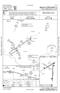
Communications frequencies: [VIEW]
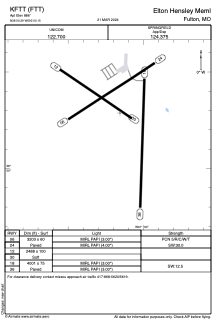
Runways:
| RWY identifier | QFU | Length (ft) | Width (ft) | Surface | LDA (ft) |
| 06 | 57° | 3203 | 60 | CONC | |
| 24 | 237° | 3203 | 60 | CONC | |
| 12 | 124° | 2488 | 100 | GRASS | |
| 30 | 304° | 2488 | 100 | GRASS | |
| 18 | 181° | 4001 | 75 | CONC | |
| 36 | 1° | 4001 | 75 | CONC |
Airport contact information
Address: Fulton United States