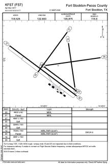


KFST - Fort Stockton-Pecos County
Located in Fort Stockton, United States
ICAO - FST, IATA - FST
Data provided by AirmateGeneral information
Coordinates: N30°54'55" W102°54'46"
Elevation is 3011 feet MSL.
Magnetic variation is 09° East View others Airports in Texas
Operational data
Special qualification required
Current time UTC:
Current local time:
Weather
METAR: KFST 291153Z AUTO 22011KT 10SM CLR 16/M08 A2994 RMK AO2 SLP096 T01561078 10183 20150 53007 $
TAF: KFST 291120Z 2912/3012 21008KT P6SM SKC FM300000 16008KT P6SM SKC
Communications frequencies: [VIEW]
Runways:
| RWY identifier | QFU | Length (ft) | Width (ft) | Surface | LDA (ft) |
| 03 | 37° | 4400 | 60 | ASPH | |
| 21 | 217° | 4400 | 60 | ASPH | |
| 07 | 82° | 4961 | 150 | GRASS | |
| 25 | 262° | 4961 | 150 | GRASS | |
| 11 | 126° | 3348 | 100 | GRASS | |
| 29 | 306° | 3348 | 100 | GRASS | |
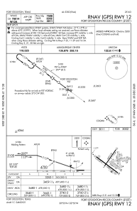
| 12 | 127° | 7508 | 100 | ASPH | |
| 30 | 307° | 7508 | 100 | ASPH | |
| 16 | 171° | 3981 | 150 | GRASS | |
| 34 | 351° | 3981 | 150 | GRASS |
Airport contact information
Address: Fort Stockton United States