


KFSD - Joe Foss Fld
Located in Sioux Falls, United States
ICAO - FSD, IATA - FSD
Data provided by AirmateGeneral information
Coordinates: N43°34'55" W96°44'31"
Elevation is 1429 feet MSL.
Magnetic variation is 05° East View others Airports in South Dakota
Operational data
Special qualification required
Current time UTC:
Current local time:
Weather
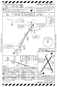
METAR: KFSD 290656Z AUTO 28013G23KT 3SM BR OVC005 08/06 A2971 RMK AO2 RAE46 SLP066 P0000 T00780056 $
TAF: KFSD 290520Z 2906/3006 31011KT 3SM BR VCSH OVC008 FM291200 29013G21KT 3SM BR OVC006 FM291500 29014G20KT P6SM OVC006 FM291900 28014G23KT P6SM BKN013 FM292300 29012G18KT P6SM BKN022 FM300100 VRB04KT P6SM FEW022
Communications frequencies: [VIEW]
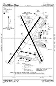
Runways:
| RWY identifier | QFU | Length (ft) | Width (ft) | Surface | LDA (ft) |
| 03 | 35° | 9000 | 150 | CONC | 8999 |
| 21 | 215° | 9000 | 150 | CONC | 8999 |
| 09 | 103° | 3151 | 75 | CONC | |
| 27 | 283° | 3151 | 75 | CONC | |
| 15 | 155° | 8000 | 150 | CONC | 8000 |
| 33 | 335° | 8000 | 150 | CONC | 8000 |
Airport contact information
Address: Sioux Falls United States
