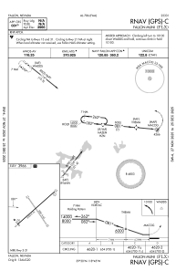
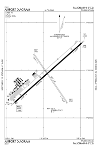


KFLX - Fallon Muni
Located in Fallon, United States
ICAO - FLX, IATA - FLX
Data provided by AirmateGeneral information
Coordinates: N39°29'57" W118°44'56"
Elevation is 3966 feet MSL.
Magnetic variation is 14° East View others Airports in Nevada
Operational data
Special qualification required
Current time UTC:
Current local time:
Weather at : KNFL - Fallon Nas (Van Voorhis Fld) ( 10 km )
METAR: KNFL 262356Z COR 30018G26KT 10SM -RA SCT050 BKN100 BKN150 BKN250 13/M02 A2982 RMK AO2 PK WND 30029/2331 WSHFT 2318 RAB55 SLP076 CB DSNT NE-E-SE SH VC ALQDS 60000 P0000 T01281017 10156 20106 55004
TAF: TAF KNFL 2623/2723 33012G18KT 9999 SCT050CB BKN100 BKN250 640506 QNH2974INS TEMPO 2700/2704 VRB20G30KT 8000 -TSRA SCT030 BKN050CB OVC070 FM270600 32010G15KT 9999 VCSH SCT050 BKN100 BKN250 650406 QNH2982INS FM270900 33008KT 9999 FEW050 SCT100 SCT180 600000 QNH2988INS AUTOMATED SENSOR METWATCH 2707 TIL 2716 TX13/2623Z TN03/2713Z FS30123
Communications frequencies: [VIEW]
Runways:
| RWY identifier | QFU | Length (ft) | Width (ft) | Surface | LDA (ft) |
| 03 | 48° | 5705 | 75 | ASPH | |
| 21 | 228° | 5705 | 75 | ASPH | |
| 13 | 146° | 3581 | 60 | EARTH | |
| 31 | 326° | 3581 | 60 | EARTH |
Airport contact information
Address: Fallon United States