


KFHR - Friday Harbor
Located in Friday Harbor, United States
ICAO - FHR, IATA - FRD
Data provided by AirmateGeneral information
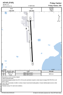
Coordinates: N48°31'19" W123°1'28"
Elevation is 112 feet MSL.
Magnetic variation is 16° East View others Airports in Washington
Operational data
Special qualification required
Current time UTC:
Current local time:
Weather
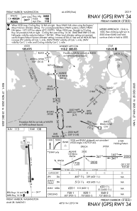
METAR: KFHR 281553Z AUTO 24007KT 10SM BKN041 OVC050 10/03 A3002 RMK AO2 SLP164 T01000033 $
Communications frequencies: [VIEW]
Runways:
| RWY identifier | QFU | Length (ft) | Width (ft) | Surface | LDA (ft) |
| 16 | 177° | 3402 | 75 | ASPH | |
| 34 | 357° | 3402 | 75 | ASPH |
Airport contact information
Address: Friday Harbor United States
