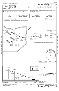
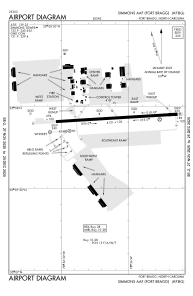


KFBG - Simmons Aaf
Located in Fort Liberty, United States
ICAO - FBG, IATA - FBG
Data provided by AirmateGeneral information
Coordinates: N35°7'55" W78°56'10"
Elevation is 244 feet MSL.
Magnetic variation is -07° East View others Airports in North Carolina
Operational data
Special qualification required
Current time UTC:
Current local time:
Weather
METAR: KFBG 140828Z 00000KT 10SM SCT055 19/17 A2997 RMK AO2A RAB15E28 SLP150 $
TAF: TAF AMD KFBG 140140Z 1401/1507 15006KT 9999 BKN050 OVC100 QNH3003INS BECMG 1408/1409 11004KT 9000 -RA BKN015 OVC080 QNH3001INS BECMG 1411/1412 12006KT 6000 RA BKN009 OVC030 QNH3001INS BECMG 1417/1418 14009KT 9000 -SHRA BKN008 OVC025 QNH2992INS BECMG 1420/1421 15006KT 9000 -SHRA BKN008 OVC020 QNH2986INS BECMG 1501/1503 17009KT 9999 NSW OVC008 QNH2981INS TX24/1419Z TN17/1410Z
Communications frequencies: [VIEW]
Runways:
| RWY identifier | QFU | Length (ft) | Width (ft) | Surface | LDA (ft) |
| 09 | 86° | 5011 | 110 | ASPH | |
| 27 | 266° | 5011 | 110 | ASPH |
Airport contact information
Address: Fort Liberty United States