


KFBG - Simmons Aaf
Located in Fort Liberty, United States
ICAO - FBG, IATA - FBG
Data provided by AirmateGeneral information
Coordinates: N35°7'55" W78°56'10"
Elevation is 244 feet MSL.
Magnetic variation is -07° East View others Airports in North Carolina
Operational data
Special qualification required
Current time UTC:
Current local time:
Weather
METAR: KFBG 300055Z AUTO 16003KT 10SM CLR 24/13 A3003 RMK AO2 SLP170 T02440130 $
TAF: TAF COR KFBG 300111Z 3001/0107 22008KT 9999 SKC QNH3002INS BECMG 3005/3006 21008KT 9999 SKC WS010/22030KT QNH3003INS TEMPO 3009/3012 8000 BR FEW020 BECMG 3014/3015 22010G15KT 9999 FEW050 SCT150 510003 QNH2993INS BECMG 0100/0101 20010KT -SHRA 8000 SCT030 BKN040 QNH2993INS TX28/3020Z TN16/3011Z
Communications frequencies: [VIEW]
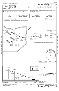
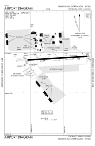
Runways:
| RWY identifier | QFU | Length (ft) | Width (ft) | Surface | LDA (ft) |
| 09 | 86° | 5011 | 110 | ASPH | |
| 27 | 266° | 5011 | 110 | ASPH |
Airport contact information
Address: Fort Liberty United States