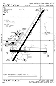


KFAY - Fayetteville Rgnl/Grannis Fld
Located in Fayetteville, United States
ICAO - FAY, IATA - FAY
Data provided by AirmateGeneral information
Coordinates: N34°59'28" W78°52'49"
Elevation is 189 feet MSL.
Magnetic variation is -07° East View others Airports in North Carolina
Operational data
Special qualification required
Current time UTC:
Current local time:
Weather
METAR: KFAY 291253Z 24011KT 10SM CLR 19/14 A3017 RMK AO2 SLP210 T01940144
TAF: KFAY 291120Z 2912/3012 21008KT P6SM SKC FM291600 21009G16KT P6SM FEW050 FM300000 19007KT P6SM FEW200 TEMPO 3009/3012 3SM BR SCT002
Communications frequencies: [VIEW]
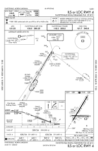
Runways:
| RWY identifier | QFU | Length (ft) | Width (ft) | Surface | LDA (ft) |
| 04 | 31° | 7709 | 150 | ASPH | 6508 |
| 22 | 211° | 7709 | 150 | ASPH | 6413 |
| 10 | 91° | 4801 | 150 | ASPH | |
| 28 | 271° | 4801 | 150 | ASPH |
Airport contact information
Address: Fayetteville United States
Other aviation service providers
Repair station

Flight schools

All American Aviation Services, Llc
All American Aviation Services, Llc
allamericanaviationservices@gmail.com+1(910)644-8817
Fayetteville Technical Community College
Fayetteville Technical Community College
ceonline@faytechcc.edu+1(910)678-8431