


KFAF - Felker Aaf
Located in Fort Eustis, United States
ICAO - FAF, IATA - FAF
Data provided by AirmateGeneral information
Coordinates: N37°7'57" W76°36'32"
Elevation is 11 feet MSL.
Magnetic variation is -11° East View others Airports in Virginia
Operational data
Special qualification required
Current time UTC:
Current local time:
Weather
METAR: KFAF 040125Z AUTO 12009G15KT 7SM OVC005 14/12 A3010 RMK AO2 SLP196 $
TAF: TAF KFAF 031800Z 0318/0424 07015G20KT 9999 SCT020 SCT050 BKN250 QNH3002INS BECMG 0319/0320 07015G20KT 9999 SCT007 BKN010 BKN020 QNH3003INS BECMG 0400/0401 08006KT 9000 BR SCT005 BKN007 OVC010 QNH3007INS BECMG 0418/0419 09012KT 9999 NSW OVC015 QNH3010INS BECMG 0422/0423 10015KT 8000 BR BKN020 OVC030 QNH3010INS TX19/0418Z TN14/0401Z
Communications frequencies: [VIEW]
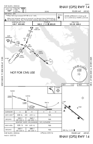
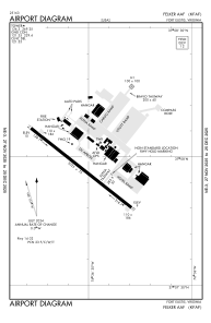
Runways:
| RWY identifier | QFU | Length (ft) | Width (ft) | Surface | LDA (ft) |
| 14 | 128° | 3025 | 75 | ASPH | |
| 32 | 308° | 3025 | 75 | ASPH | |
| H1 | 0° | 0 | 0 | UNK |
Airport contact information
Address: Fort Eustis United States