


KEOP - Pike County
Located in Waverly, United States
ICAO - EOP, IATA -
Data provided by AirmateGeneral information
Coordinates: N39°10'1" W82°55'42"
Elevation is 661 feet MSL.
Magnetic variation is -06° East View others Airports in Ohio
Operational data
Special qualification required
Current time UTC:
Current local time:
Weather at : KRZT - Ross County ( 31 km )
METAR: KRZT 300855Z AUTO 03003KT 5SM SCT040 SCT048 SCT065 16/16 A2993 RMK AO2 P0010 PWINO
Communications frequencies: [VIEW]
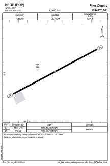
Runways:
| RWY identifier | QFU | Length (ft) | Width (ft) | Surface | LDA (ft) |
| 07 | 62° | 4899 | 75 | ASPH | |
| 25 | 242° | 4899 | 75 | ASPH |
Airport contact information
Address: Waverly United States